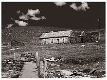
Slea Head
Slea Head is a promontory on the westernmost part of the Dingle Peninsula, in southwest County Kerry, Ireland. It can be reached by the R559 road, with the nearest villages being Ballyickeen and Coumeenoole. The headland itself, together with the larger part of Mount Eagle's southern slopes, is formed from steeply dipping beds of the pebbly sandstones and conglomerates of the Slea Head Formation, dating from the Devonian period and traditionally referred to as old red sandstone.
Read article
Top Questions
AI generatedMore questions
Nearby Places

Dunquin
Village in County Kerry, Ireland

Beiginis
Island in Ireland

MV Ranga

Mount Eagle (Ireland)
Mountain in Kerry, Ireland

Dunmore Head
Place in Kerry, Ireland

Glanfahan
Townland on the Dingle Peninsula, Ireland

Rinn an Chaisleáin
Castle site, cillín in County Kerry, Ireland

Coumeenoole
Village in Munster, Ireland


